
More dramatic pictures of storm damage...
Monday 28th - 8.42
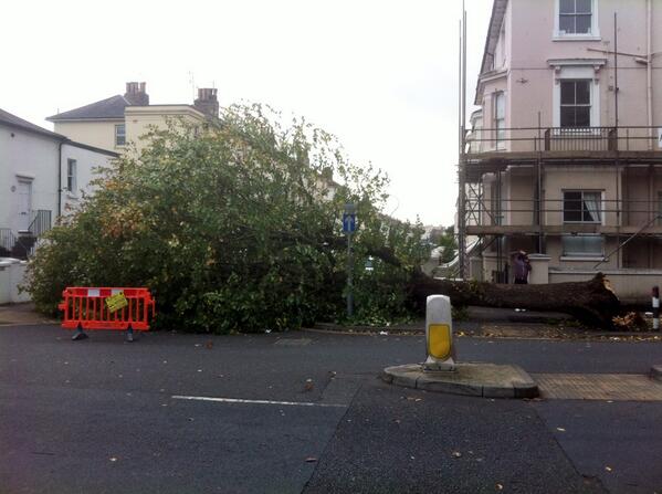
Fallen tree - Just by Fleet Road in #NW3 #ukstorm pic.twitter.com/0vIddukSRb
— Tanya Cordrey (@tcordrey) October 28, 2013
Willow tree snapped in two near Hatfield House Mill Green entrance The Ryde area. #storm pic.twitter.com/H24cyQVF0k
— Alan Davies (@alpdavies) October 28, 2013
Monday 28th - 8.22
140,000 homes without power across the area of the storm.
Monday 28th - 8.10
Dramatic images of storm damage start to appear on social networks...
The #storm has arrived in Canary Wharf pic.twitter.com/9LUung9Pau
— Jacob Diggle (@JacobDiggle) October 28, 2013
Horrible morning for someone #storm #stjude pic.twitter.com/SaQ74Ythuz
— Will Nichols (@WillNicholsRisk) October 28, 2013
https://twitter.com/chrischarles101/statuses/394723294320295936
#UKstorm Image of a tree on the line at Keymer (pic) pic.twitter.com/BNlICO9bTG
— Network Rail (@networkrail) October 28, 2013
Monday 28th - 8.00
Flood warnings no longer restricted to the South West, 2 new warnings in the South East... Lindfield Bridge, River Ouse and Ryde on the Monktonmead Brook. There are now 12 flood warnings in force across the South West and South East.
Monday 28th - 7.45
Downing street crane crashes into cabinet office...
As the winds seem to pass the crane from downing St that crashed into cabinet office and bits fell into Rd pic.twitter.com/K6SWQQtT6t
— PoliticalPics (@PoliticalPics) October 28, 2013
Monday 28th - 7.36
40,000 homes across the South East are without power. Areas affected are Bedfordshire, Hertfordshire, Essex, Sussex, Surrey and Kent.
The storm is now tracking North Eastwards and strong winds are expected in East Anglia in the next few hours.
Monday 28th - 7.22
Several people are seen at Brighton see front preparing to take a swim. This is seriously not advised.
https://twitter.com/oliviarichwald/statuses/394722839720656896
https://twitter.com/oliviarichwald/statuses/394723844881403904
Monday 28th - 07.10
During the night, hundreds of trees have fallen, many onto roads, surface flooding affecting many roads and many train services cancelled until later this morning. This mornings commute is going to be difficult. Consider if your journey is absolutely necessary.
Many people waking up to find damage to their property...
Yeahh good one wind pic.twitter.com/rvnT9F8OTk
— lucia (@Lucia_luisa_) October 28, 2013
https://twitter.com/zaihelmss/statuses/394716699968438272
UK wind storm - Damage to our property..(Essex) see the picture attached) pic.twitter.com/8K455nEqdX
— Joachim Adenusi (Oga Risk) (@Joachim_Adenusi) October 28, 2013
Monday 28th - 06.55
The Government post a response to the storm on the Gov.uk website giving plans and advice for the storm that has been causing disruption to parts of the UK.
Monday 28th - 06.00
First footage of last nights storm, the damage and the clear up efforts appear on BBC TV News.
Monday 28th - 05.55
Sussex police Tweet that the Met Office have told them that the worst is still to come.
Just getting up? Met Office tells us worse of the wind still to come. Do you really need to go out yet? If so, be careful. #sussexstorm
— Sussex Police (@sussex_police) October 28, 2013
Disruption to rail services throughout the South of England including First Capital Connect, London Overgound, Network south East, Greater Anglia, Stansted Express and East Midlands. Check service status before your head out.
17 serious flood warnings now. See the Environment Agency flood warning map for latest warnings.
Monday 28th - 05.30
Damaging wind now being reported in Somerset. It seems the winds to rear of the low are particularly strong.
Damaging gusts NOW across Yeovilton, Somerset with 75mph recorded. Take care out there and delay your journey this morning if you can. Lou L
— BBC Weather (@bbcweather) October 28, 2013
Wind at the Needles, Isle of White is getting even stronger...
Current maximum wind gust recorded at 5am is 99mph at Needles Old Battery - Isle of Wight. ^TLH
— Met Office (@metoffice) October 28, 2013
At least 7000 homes now without power in SW England...
7000 properties are without power across Western Power Distribution's South West area from Bath downwards. #storm2013
— Hamish Marshall (@hamish_mmm) October 28, 2013
Monday 28th - 04.10
Cornwall now getting strong winds from the rear side of the Low...
In Cornwall, we have recently seen winds gusting to just over 55mph, as they swung to the west, on the rear side of the low. #storm2013
— Hamish Marshall (@hamish_mmm) October 28, 2013
Monday 28th - 03.45
Gusts of up to 60mph reported in Sussex and the worst is yet to come...
Just talked to man from the Met Office who says that they've recorded 60mph+ gusts at Shoreham and Herstmonceux. #sussexstorm
— Sussex Police (@sussex_police) October 28, 2013
Monday 28th - 03.40
Lots of surface flooding and many fallen trees, and for some, the worst is yet to come. Travel tomorrow morning is going to be severely disrupted in all areas affected by the storm. Consider whether you journey is essential and cut out or delay all but essential travel.
Already seeing some localised #flooding #storm #sussexstorm #crawley pic.twitter.com/91JJ3TV16j
— Paul Gilbert 🎧 (@PaulGilbertDj) October 28, 2013
https://twitter.com/RichCross2013/statuses/394664080545296384
Hampshire Fire and Rescue Service says it's had about 6 call outs for fallen trees. Crews are braced for more as the #ukstorm develops.
— Joe Tidy (@joetidy) October 28, 2013
Monday 28th - 03.30
Emergency services already very busy. Please only call 999 in a real emergency. To report fallen trees or less urgent problems please call 101.
Monday 28th - 03.05
10 serious flood warnings now. See the Environment Agency flood warning map for latest warnings.
Monday 28th - 02.50
The storm is intensifying in the South East...
Power cuts reported in Maresfield, Sussex...
2nd power cut in the last 45 mins. Heavy rain and winds rising in Maresfield #sussexstorm
— Kieran Hewitt (@kieranhewitt) October 28, 2013
Police car damaged by falling tree on B2104...
And it happens to us! Police car damaged by falling tree on B2104 Mayfield Flat. Blocked road and BT cable brought down in #sussexstorm
— Sussex Police (@sussex_police) October 28, 2013
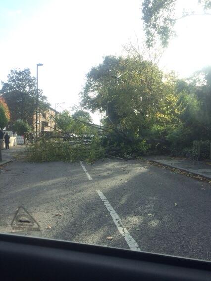
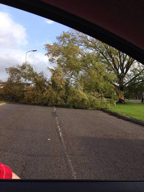
The number of fallen trees in the South of England is increasing all the time, please be careful if your are out in this.
Monday 28th - 02.15
There are now 144 flood alert and 6 more serious flood warnings. See the Environment Agency flood warning map for latest warnings.
Monday 28th - 01.45
A large tree has fallen on taxi at The Goffs in Eastbourne. Thankfully nobody injured. Sussex police say it could take a while to clear.
Big tree fallen on taxi at The Goffs in Eastbourne. Thankfully nobody injured. Could take a while to clear. #sussexstorm
— Sussex Police (@sussex_police) October 28, 2013
Tree on taxi in Goffs Road, Eastbourne driver walked away uninjured. Very fortunate #sussexstorm pic.twitter.com/FlxeG9pcht
— Sussex Roads Police (@SussexRoadsPol) October 28, 2013
Monday 28th - 01.35
Fallen tree blocks all rail lines at Botley, Hampshire...
https://twitter.com/JourneyCheckSWT/statuses/394638194127290369
More trees down blocking roads. As the storm becomes stronger it is clear that travel tomorrow morning will be severely disrupted.
The Goffs in Eastbourne is blocked. Tree fallen on taxi - no injuries #sussexstorm
— Sussex Roads Police (@SussexRoadsPol) October 28, 2013
Report of fallen tree blocking one side of road between Mawnan Smith and Mabe at crossroads for Argal reservoir #floodaware
— @cornwallcouncil (@CornwallCouncil) October 28, 2013
Paddock Wood, Maidstone Rd: Large fallen tree blocking the width of the entire carriageway. Please seek alternative route.
— KCC Highways (@KentHighways) October 28, 2013
Monday 28th - 01.20
Winds in the South of England are now increasing, gusts of 40mph inland and 60mph on the coast have been recorded.
Strongest gust recorded so far is 92mph at Needles Old Battery - Isle of Wight.
Sussex police report a Tree down across the A259 in Bognor...
Tree down across the A259 Felpham Way at Bognor. Looking to divert traffic down Summerley Lane. #sussexstorm
— Sussex Police (@sussex_police) October 28, 2013
And fallen tree blocks Nutwell Road, Lympstone...
#ukstorm2013 Fallen tree blocking road Nutwell Road Lympstone - road completely blocked
— DevonAir Radio (@devonairradio) October 28, 2013
Monday 28th - 01.00
Our Facebook followers tell us of heavy rain and strong winds. Let us know what's happening where you are.
Allison Carter - Heavy rain gusting winds in weymouth dorset blowing a hooley out there
Monday 28th - 00.30
Ships just off shore on the south coast record wind speeds of 80mph.
The current highest wind speed recorded in the storm is 83mph at Needles Old Battery, Isle of Wight.
Rain falling at a rate of 5 - 10mm per hour in the South. Surface flooding expected.
Highway flooding and a few fallen trees reported in Wiltshire.
Sunday 27th - 23.35
At this point the storm centre is currently about 20 miles due north of Falmouth, moving NE at about 45mph, and deepening all the while.
Sunday 27th - 23.25
107mph wind recorded on the Isles of Scilly ...
RT @Dartmoor_SRTA: 108mph wind measured on St Martin's on the Scillies at 23:07 #ukstorm2013 #cornwall pic.twitter.com/ATOj4zCjBg
— VirtualAstro (@VirtualAstro) October 27, 2013
Reports start to emerge on twitter that Plymouth flooding is getting a lot worse...
#HeartNews Reports from @Plympolicewco that properties flooded on Shakespeare Road Honicknowle. @plymouthcc on way #swstorm
— Heart South West (@heartsouthwest) October 27, 2013
"@PlymouthHerald: Hoe Road is closed due to high waves. Police urging people to avoid area and not sightsee #storm #plymouth" @PlymHoe
— Hannah Pooley (@FudgeGecko) October 27, 2013
Highest gusts recorded so far tonight are 63mph at Culdrose, Cornwall and 61mph at Plymouth, Devon.
Sunday 27th - 22.47
Minor surface flooding being reported on roads in South of England.
Picture - flooding in Plymouth tonight. http://t.co/B9yEl5bXkJ
— Ian Axton (@IanAxton) October 27, 2013
Sunday 27th - 21.40
Lots more flood warnings issued by Environment agency. Check for floods in your area.
Flood Warnings so far...
Chiswell, West Bay Harbour, Lyme Regis Harbour.
Sunday 27th - 21.30
BBC report on Twitter that high winds in Berkshire has cut power to 1000 homes (Though this seems to have happened earlier today)...
BBC News - High winds in Berkshire cut power to 1,000 homes http://t.co/jy6GxCli44
— BBC South (@BBCSouthNews) October 27, 2013
Sunday 27th - 21.00
Twitter users start to report increasing wind and rain ahead of the storm...
https://twitter.com/lmfaojessicaa/statuses/394569087160160256
#ukstorm update: now I`m really getting worried: leaves falling off the trees and swirling in the wind @SkyNews where are you?
— Ioan Dyer (@Ioan_Dyer) October 27, 2013
https://twitter.com/housey95/statuses/394570722577633280
https://twitter.com/hgrry/statuses/394571575938523136
Sunday 27th - 20.30
Highways Agency announce that the the Queen Elizabeth II bridge on the M25, which forms part of the Dartford River Crossing is likely to close in the early hours of the morning.
Authorities on both sides of the Severn have taken the decision to also close the second Severn Crossing, the M4, from 3am on Monday.
60 flights have been cancelled at London's Heathrow Airport tomorrow due to the expected storm.
Sunday 27th - 20.00
#ukstorm starts trending on Twitter
Sunday 27th - 19:25
Eurostar report that due to weather conditions, service will be suspended until 7am.
Gatwick Airport issue travel warning...
With a Met Office weather warning in place for very high winds over the next 24 hours, passengers due to travel on Monday are advised to check their flight status with their airline and allow plenty of time for their journey to the airport. Please note train services will not be running to or from Gatwick early Monday morning.
Anyone flying into our out of the UK tonight or tomorrow should check with their airline and airport.
Environment Agency SW report flood warnings and alerts...
We have 3 flood warnings (flooding expected), and 32 flood alerts (flooding possible) in the SW at present. More at: http://t.co/4QnrhsRex1
— Environment AgencySW (@EnvAgencySW) October 27, 2013
Sunday 27th - 19:15
More twitter users reporting power cuts...
Power cut & we were 5 mins from tea being ready ....
— Matt (@bongbrummie) October 27, 2013
https://twitter.com/DawniePaws/statuses/394540768633040896
Sunday 27th - 19:05
Twitter user reports a power cut in Newquay, Cornwall.
https://twitter.com/dogsmyjob/statuses/394521767232167936
Sunday 27th - 18:45
ITV.com publish pictures of huge waves hitting the coast at Porthcawl, South Wales.
Another fallen tree, this time in Ceredigion is reported on Twitter...
Fallen tree - A485 Ceredigion - Road blocked both ways - Llanilar and Lledrod
— James Wright (@JamesWrightTV) October 27, 2013
Another tree down in Brighton...
Fallen tree in Brighton, hours before the main storm arrives.
Another in South London...
Tree falls across a road in South London hours before the main storm arrives.
And another in Ashford, Kent...
Tree falls across road in Ashford, Kent, Hours before the main storm hits the UK.
Reports of strong winds continue to come in, hours before the main storm is due to hit.
Sunday 27th - 16.10
Followers of our Facebook page have started to report stormy weather already, and the real storm is not even with us yet.
Russell Peace - "Its getting Fruity along the sea Front in Portsmouth. The Solent is very quiet but the ferry is still running to the I of W."
Nic Burton - "It is very windy with strong gusts on portsdown hill north of Portsmouth harbour which is unusually choppy too."
Sunday 27th - 15:45
Reports of rail service changes and cancellations starting to come in.
Southern Rail...
Southern and Gatwick Express services will not run tomorrow morning until it has been declared safe to do so.
South west trains...
Projected severe weather on Sunday and Monday will affect services across our network. Please check before you travel.
East Coast Trains...
The Met Office is forecasting severe weather affecting much of the East Coast route on Monday 28 October.
Taking their advice into account and in conjunction with Network Rail, East Coast will be working to an amended timetable on Monday 28 October.
This timetable is available here
East Midlands Trains...
Heavy rain and high winds are forecast tonight and into Monday 28 October 2013.
East Midlands Trains may run an amended timetable. Information will be posted on our website when available and it is advised you check the latest travel information before starting your journey.
http://www.eastmidlandstrains.co.uk/train-times/live-train-updates/
First Capital Connect...
High winds and heavy rain are forecast across the South East of England on Sunday night and Monday morning. Services are expected to be heavily disrupted and may be suspended.
First Great Western...
Current weather forecasts indicate that there will be severe adverse weather, overnight from Sunday 27th October until mid-day on Monday 28th October. As well as rain, very strong wind speeds have been projected.
It is our key priority to run a safe railway, therefore there may be a requirement to run trains at reduced speeds for all or part of the journey.
If you are travelling with First Great Western later this evening or tomorrow morning, we would ask that you allow for an extended journey time, and that you check for current train running information on our JourneyCheck pages before starting your journey.
South Eastern Trains...
The weather forecast for tonight is for severe storms. Strong winds and heavy rainfall can cause trees and branches to fall onto the railway lines and localised flooding.
If the storm hits our region as predicted - then we may need to start train services later than usual tomorrow morning, likely around 9 or 10am. This will give Network Rail the chance to clear the tracks.
Sunday 27th - 14:45
The country is preparing itself for the possibility of a storm worse than any seen for more than a decade. No-one is quite sure how bad it will be, but Facebook and Twitter are alive with speculation and thousands of people are taking to Google to find out the latest information.
The South of England is already seeing stormy weather. The Daily Mail publish a collection of images from around the UK showing a fallen wind turbine and dramatic seas around the South coast.
80 mph winds already recorded in Pembry, South Wales...
80mph gust has already been recorded this morning at Pembrey
— James Wright (@JamesWrightTV) October 27, 2013
A tree has fallen in Aberdare, Wales, and the first power cut is recorded...
First power cuts reported: 107 homes without power in Llandarcy/Neath area following branch falling on high voltage power cable.
— James Wright (@JamesWrightTV) October 27, 2013