
The Met Office has issued a rare red extreme heat warning for Wednesday and Thursday this week, as a "heat dome" parked over the UK and western Europe pushes temperatures towards levels almost never seen on these islands. Forecasters expect highs of at least 39°C, with a real chance of touching 40°C in the worst-affected spots — and, just as dangerously, nights that barely cool down.
The red warning covers parts of central and southern England and Wales, running from 9am on Wednesday 24 June to 9pm on Thursday 25 June. It sits inside a wider amber warning that stretches from Monday right through to Thursday evening. A separate red heat-health alert from the UK Health Security Agency (UKHSA) has been issued for six regions of England — only the second time that top-level health alert has ever been used.
This article explains exactly what the red warning means, what you should do to stay safe, how often the UK has seen warnings this severe, what's happening across Europe, the climate-change question everyone is asking, how the world's hottest countries cope, and where the highest temperature on Earth has ever been recorded.
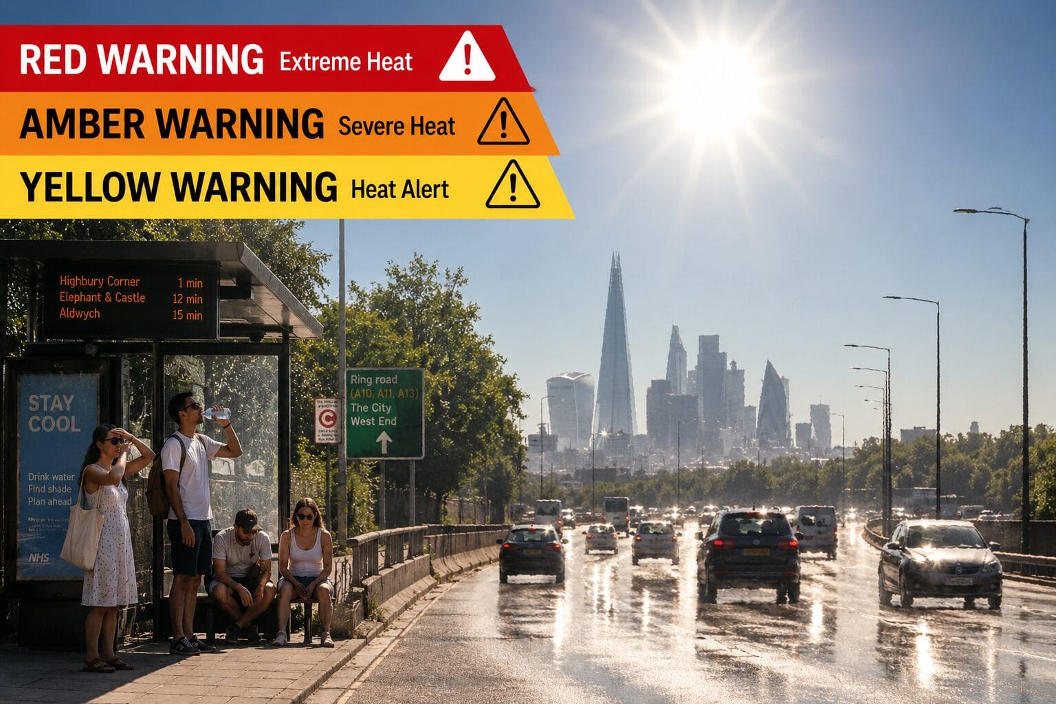
A red weather warning is the highest level of alert the Met Office issues. It is reserved for the most severe weather, where there is a likely danger to life and the potential for widespread disruption. Crucially, a red heat warning means the risk applies to everyone — not just the elderly, the very young or those with existing health conditions. Healthy adults are at risk too.
Three things make this week's heat especially dangerous:
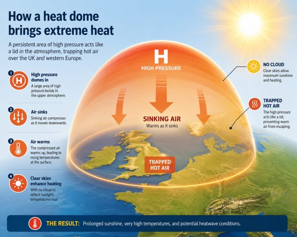
The cause is a heat dome: a vast, stalled area of high pressure that acts like a lid over the country, suppressing cloud, baking the ground with relentless sunshine, and compressing and warming the air beneath it.
It's worth understanding the difference between the two alerts you'll hear about this week. The Met Office weather warning (yellow → amber → red) is about the weather itself and its impacts on society — travel, power, water, infrastructure. The UKHSA heat-health alert (also colour-coded) is specifically about the risk to health and the pressure on the NHS and social care. This week, both have hit red at the same time, which is what makes the event so notable.
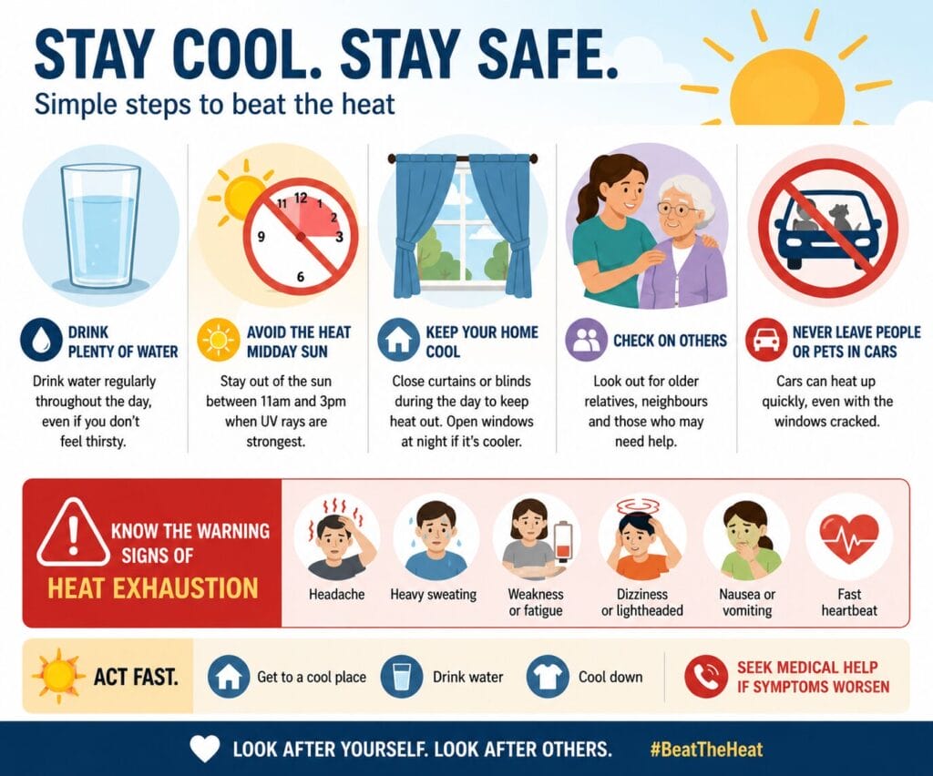
The official advice from the UKHSA and Met Office is simple but genuinely effective. The single biggest message: take it seriously, and look out for others.
Yes, but they are genuinely rare — which is exactly why this one matters. The Met Office only issues a red weather warning when it expects severe impacts and a likely danger to life, and most of the red warnings in the UK's history have been for wind and storms, not heat.
The standout heat event was July 2022, when the UK recorded its first-ever red heat warning. Temperatures passed 40°C for the first time in British history, peaking at 40.3°C at Coningsby in Lincolnshire. Train tracks buckled, runways were affected, and wildfires broke out. That event also triggered the country's first-ever red heat-health alert.
This week's warning would therefore be only the second red heat warning ever issued — and the second red heat-health alert.
For context, here are some of the other rare red warnings the Met Office has issued in recent years (the vast majority for wind):
Going further back, red weather warnings have been issued for Storm Desmond's flooding (2015), Storm Dennis (2020), and even snow in south Wales (2013). The takeaway: a red warning of any kind is a once-in-a-while event — and a red warning for heat has only happened once before.
The UK is on the cooler northern edge of a heatwave that is gripping much of western and southern Europe — the continent's second major heat event in under a month. The same heat dome responsible for Britain's warning is sitting over the continent, dragging hot Saharan air northwards over ground already bone-dry from a record-breaking spell in late May.
The picture across Europe is severe:
Tragically, the heat has also driven a sharp rise in drowning incidents across the continent as people try to cool off in rivers, lakes and the sea.

This is the question on everyone's lips — and the honest, science-based answer is nuanced but clear.
No single heatwave is "caused" by climate change in the sense that it would never have happened otherwise. Heat domes and high-pressure blocking patterns are natural features of summer weather. But that's not the right question. The right question is: has human-caused warming made an event like this more likely and more intense? And on that, the evidence is overwhelming.
The Met Office states that it is "virtually certain that human influence has increased the occurrence and intensity of extreme heat events." A growing body of attribution studies — scientific analyses that calculate how much more probable a specific event was made by climate change — has repeatedly found that human-caused warming dramatically increased the likelihood of recent UK and European heatwaves, including the summer of 2018 and July 2022.
The trend backs this up. UK heatwaves are becoming more frequent and more severe, and Met Office projections show hot spells will keep increasing in our future climate, especially across south-east England. A warmer baseline means that when a heat dome does form, it builds on already-elevated temperatures and pushes records higher. Scientists increasingly describe events like this not as freak occurrences but as "the new normal."
So the most accurate way to put it: climate change didn't single-handedly create this heatwave, but it has loaded the dice — making extreme heat hotter, longer, more humid and far more common than it would otherwise be.
For much of the world, 40°C is simply summer. Death Valley in the US, the Middle East (the UAE, Iran, Iraq, Kuwait), South Asia (India and Pakistan), Australia and parts of Africa regularly see 45°C and beyond. So how do they live with it — and what can the UK learn?
Behaviour and routine. Across southern Europe and the Middle East, daily life bends around the heat: the midday siesta, shuttered windows, early-morning and late-evening activity, and shaded public spaces. Workers in the Gulf are often banned from outdoor labour during peak afternoon hours in summer.
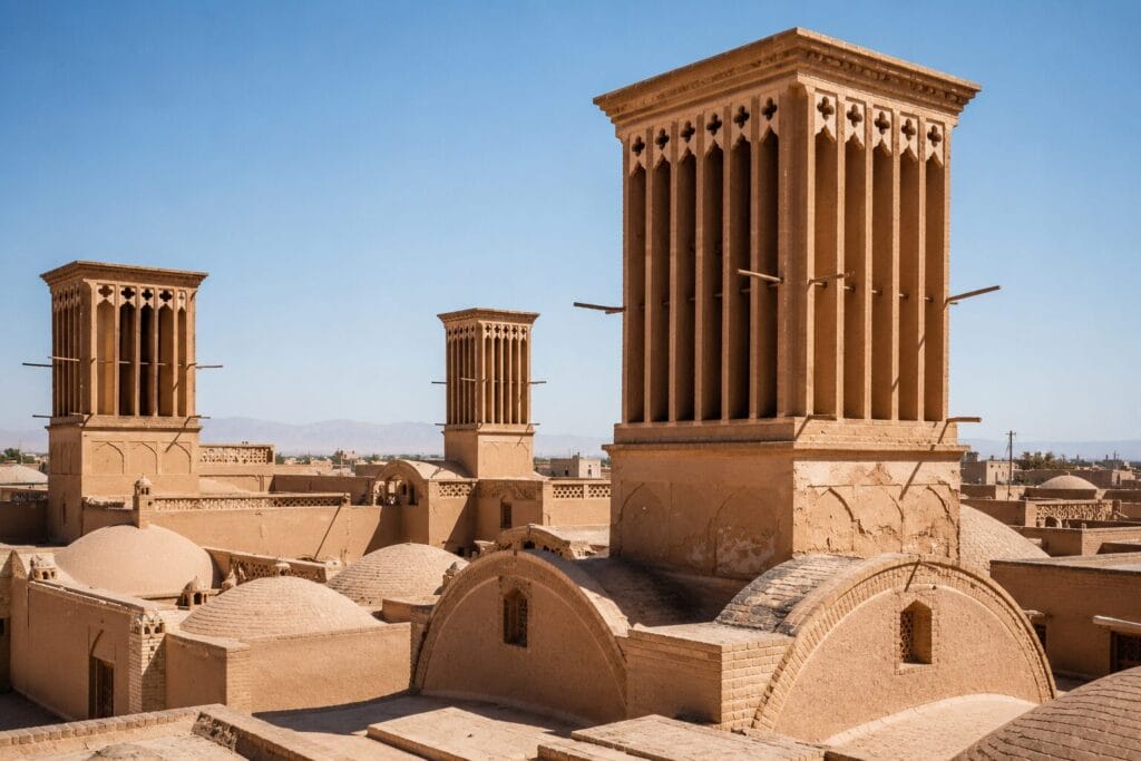
Architecture built for heat. Long before air conditioning, hot regions developed brilliant passive-cooling designs. The historic Iranian city of Yazd is famous for its badgirs (windcatchers) — tall towers that funnel breezes down into buildings and draw hot air out, with no electricity at all. Ventilated domes across the Middle East, Africa and India use the same chimney effect. Thick earthen walls, internal courtyards, shaded verandas, and the whitewashed buildings of Greece all keep interiors cool by resisting temperature swings.
Technology and planning. Air conditioning is the obvious answer, but it's far from universal: fewer than a third of the world's households have AC, and only around 8% of people in the very hottest regions own one. AC also creates a vicious cycle — it dumps heat into city streets, worsening the urban heat-island effect, and the units themselves are energy-hungry. Many hot countries now run heat action plans, cooling centres and early-warning systems; India's city-level plans are often cited as a model.
The uncomfortable truth for Britain is that the UK is poorly adapted to heat. Our homes are designed to trap warmth for cold winters, AC is rare in housing, and our infrastructure — railways, roads, hospitals — was built for a cooler climate. Hot countries cope because they've spent generations adapting; the UK is only just beginning to.
The official record for the highest air temperature ever measured on Earth belongs to Furnace Creek (then Greenland Ranch) in Death Valley, California, where the US Weather Bureau logged 56.7°C (134°F) on 10 July 1913. This figure is recognised by the World Meteorological Organization (WMO).
There's a catch, though: many meteorologists doubt it. Critics argue the 1913 reading was likely the result of observer error or a sandstorm affecting the equipment, pointing out that the region has rarely come close to that figure since. If the record were ever decertified, the highest reliable temperature on Earth would be 54.4°C (130°F), also recorded in Death Valley, on 16 August 2020.
A few more record-holders worth knowing:
For perspective: scientists believe humans cannot survive for long in temperatures above around 50°C. The "wet-bulb" limit — a measure combining heat and humidity — is 35°C, the point at which even a fit, resting person in the shade cannot cool down, no matter how much water they drink. That's why this week's combination of high heat and high humidity is so concerning, even though the UK won't come anywhere near Death Valley's numbers.

Photo by Matteo Di Iorio on Unsplash
This week's red warning is a serious, record-threatening event — the second red heat warning in UK history, and the first ever to combine extreme heat with oppressive humidity. The peak comes on Wednesday and Thursday, when temperatures could reach or exceed 39–40°C and nights may stay above 20°C. The risk is real for everyone, not just the vulnerable.
The advice is straightforward: stay out of the midday sun, keep hydrated, keep your home cool, plan around travel disruption, and check on the people around you. Most heat-related harm is preventable with a bit of care and common sense.
The bigger picture is harder to ignore. Warnings like this used to be once-in-a-generation; now they're arriving every couple of summers. Whatever the forecast says for the weekend, the long-term trend is pointing in one direction — and adapting to a hotter UK is fast becoming one of the defining challenges of British life.
Stay weather-aware, stay safe, and keep an eye on the forecast as the situation develops.

The red warning runs from 9am Wednesday 24 June to 9pm Thursday 25 June, with Wednesday and Thursday forecast as the peak. The wider amber warning covers Monday through Thursday evening, and Friday should turn less hot.
Parts of central and southern England and Wales — broadly an area stretching from London to Swansea and from Somerset up to Birmingham. The amber warning covers a much larger area of southern and central England and Wales, reaching as far north as Leeds and Liverpool on the hottest days. Always check the Met Office site for the precise, up-to-date boundaries for your postcode.
Highs of at least 39°C are forecast, and there is a genuine chance of 40°C being reached or exceeded in the hottest spots. The UK's June record of 35.6°C is very likely to be broken either way.
A tropical night is one where the temperature never drops below 20°C. It matters because your body relies on cooler nights to recover from daytime heat. Several tropical nights in a row place sustained strain on the heart and are strongly linked to rises in heat-related deaths.
Amber means significant impacts are likely and you should change your plans; the risk is greatest for the vulnerable. Red is the highest level — it signals a likely danger to life for everyone, healthy people included, and the potential for widespread disruption to travel, power and water.
The Met Office weather warning describes the weather and its impact on society. The UKHSA heat-health alert is specifically about the risk to health and pressure on the NHS. This week both have reached red simultaneously.
Strenuous activity in the hottest part of the day (11am–3pm) is best avoided. If you must work or train outside, do it early or late, take frequent breaks in the shade, and drink water steadily. Stop immediately if you feel dizzy, sick or confused.
Heat exhaustion includes heavy sweating, dizziness, headache, cramps and nausea — move to a cool place, rehydrate and cool the skin. If symptoms don't improve within 30 minutes, or if someone is confused, has stopped sweating, has a very high temperature, or collapses, this is a medical emergency: call 999.
Not in isolation — heat domes are natural. But human-caused warming has made extreme heat events like this significantly more likely, more intense and more frequent. The Met Office considers it virtually certain that human influence has increased the occurrence and intensity of extreme heat.
July 2022 was hotter at its absolute peak (the UK's record 40.3°C) but drier and shorter. This week is forecast to be longer-lasting and far more humid, which can make it feel more oppressive and dangerous for the general population, even at slightly lower peak temperatures.