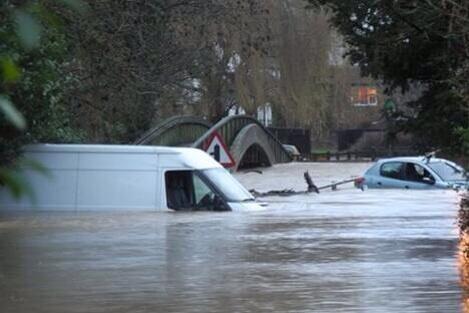
Latest: River levels in the Mole and its tributaries have been steadily falling since Christmas Day but still remain high. Between 10 to 20 mm of rainfall is currently expected between midnight and 8 o'clock on Friday morning. This is likely to result in the River Mole overtopping its banks in places during Friday afternoon and into Saturday, which will flood low lying land and roads. Property flooding is not currently expected, but we will continue to monitor the situation and issue any flood warnings if property is threatened.
Towns in the Mole valley have been affected by sever flooding as the river Mole bursts it's banks. Flooding in Dorking has been particularly bad.
Earlier we reported how Leatherhead, another town on the river Mole was the subject of a severe flood warning issued by the Environment Agency. A severe flood warning means that there is imminent danger to life.
On Christmas day, thundery showers continued to hit the the South East making the situation even worse. Heavy hail showers have been crossing the south east (See pictures and video of the hail showers).
This video uploaded to Youtube by Lewis Walsey shows a car stranded in flood water on a road near to Dorking (contains language not suitable for children)...
Incredible pictures of the flooding have appeared on Twitter...
River mole floods in Pixham, #dorking @dorkingnews pic.twitter.com/clzbGowrTn
— Jane Wilbur (@janewilbur) December 24, 2013
Xmas Eve 2013, #UKstorm flooding at #Brockham bridge, #Surrey. Incredible no one died. #Dorking #Reigate. pic.twitter.com/CNyr46ziGo
— BrexitWatch 💎 (@BrexitWatch007) December 24, 2013
More flooding in Pixham, #dorking @dorkingnews pic.twitter.com/uCyZibOVDS
— Jane Wilbur (@janewilbur) December 24, 2013
https://twitter.com/chelseaknightx/statuses/415475054890475520