New - See our live, as it happens report on the storm. Trees down, Power cuts reported.
By now you have probably heard that there is a big storm predicted for the South of England, South Wales and East Anglia on Monday the 28th October. You are now probably wondering just how likely it is that this storm will hit us.
See our latest advice on what to do to prepare for this storm.
Well, as I write this, the storm doesn't actually exist (Update: Storm now exists and is heading for the UK as predicted), but weather patterns are developing in a similar way to how storms of this type regularly form. This type of storm is a regular occurrence at this time of year over the Atlantic. The difference with this storm is that if it does develop, it will develop much closer to the UK than usual, and if it does hit us, when it does it will be at full strength or even still increasing in strength. Usually these storms happen over the Atlantic ocean and have lost intensity by the time they reach us.
It is very likely that the storm will happen, but is not definite, so a lot of weather forecasters are wary of saying that it is actually going to happen for sure, they don't want to be seen to make a huge incorrect prediction as Michael Fish did before the great storm of 1997.
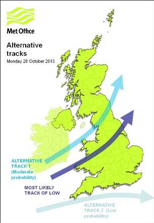
The main uncertainty is not whether it will happen, it is how severe it will be and what course it will take. At the moment it looks as though it will pass over the middle of England in the early hours of Monday, with the worst of the wind hitting the South. However, as the storm has not even formed yet, there can be no certainty of the course it will take or what time it will hit.
The image on the left shows the possible tracks the storm could take. As you can see, there is a possibility that the storm could pass below the UK, leaving us with much less severe weather. There is also a possibility that it could pass over the UK further North, which would bring severe winds and rain further North than currently predicted. The most likely track is across the middle of Wales and the Midlands of England, with the most severe weather in the South of England, South Wales and East Anglia.
If the storm does develop and is as severe as predicted, and it takes a course over the UK, we should expect winds of 60 - 80 mph and over 80 mph in open areas such as coast lines. There will be a possibility of downed trees, structural damage an power outages.
People should keep a close eye on the weather forecast over the weekend as we get a better idea of what's coming. Click 'Like' our Facebook page to get regular updates on your Facebook news feed. We will be following the development of this storm very closely.
Update: The storm is now almost certain and will begin to hot England late on Sunday night. Read more