
Yet another storm is set to hit our coast in the early hours of Friday 3rd January 2014, bringing gale force winds and potential coastal and local flooding.
A low pressure weather system, high tides and strong winds are likely to cause a tidal surge that will bring real risk of flooding to coastal regions at hight tide, particularly in the south west of England.
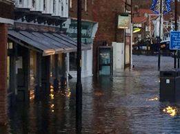
In the last few weeks the UK has been subjected to a succession of sever gale force winds, heavy rain, sleet, hail and snow, severe local flooding caused by long periods of heavy rain and a tidal surge that caused severe flooding and damage to towns on the East coast. When more rain arrives tomorrow, it will fall on already saturated ground, already high river levels could bring even more local flooding inland and high winds coupled with a naturally high spring tide, could bring severe tidal flooding to many coastal towns in Wales and on the West and south coast of England.
There are currently 13 severe flood warnings in the south west of England, and 1 for Wales. Severe flood warnings mean that there is risk of severe flooding and danger to life. There are also 135 flood warnings (Flooding is expected. Immediate action required), one level down from a severe flood warning, and 239 flood alerts. All severe flood warnings are detailed below.
The Met office have also issued yellow warnings of wind and rain for the whole of the West coast, and South coast of the UK. Gusts are expected to reach up to 70mph on exposed coasts, 80mph on some exposed Irish sea coasts, and 50mph inland.
The storm and tidal surge are likely to cause severe disruption to travel in affected areas, and possible damage to property in areas affected by floods. There is also a possibility of disruption to power supply.
Severe flood warnings in place at the moment...
South West England
Preston beach. The Sea Life Centre and the Preston Beach Road area of Lodmore. There may be significant spray and shingle overtopping affecting the coast road which will be very dangerous to life, property and traffic. The time and date of the forecast high water for which this SEVERE Flood Warning is in force is : 9:00am.
Plymouth Barbican. Plymouth Barbican including Sutton Harbour. Overtopping of coastal defences is likely with high energy large waves and spray combined with high spring tides and high winds. The local time of high water on 03 JAN 2014 is 06:50 at Devonport. At Devonport the predicted astronomical tide level is 2.75mAOD. The forecast surge height is 0.6m. Conditions will usually apply 2-4 hours either side of high tide.
North Cornwall Coast At Wadebridge. North Cornwall Coast At Wadebridge including Harbour Road, The Platt, Eddystone Road, Southern Way, Jubilee Road, Egloshayle and Sladesbridge. The local time of high water on 03 JAN 2014 is 06:22 at Padstow and 06:50 at Illfracoombe. At Ilfracombe the predicted astronomical tide level is 5.16 mAOD. The forecast surge height is 0.8m. Overtopping of coastal defences is likely with high energy large waves and spray combined with high spring tides and high winds. Conditions will usually apply 2-4 hours either side of high tide.
North Cornwall Coast At Bude. North Cornwall Coast At Bude including The Strand and The Crescent. The local time of high water on Friday 3rd January 2014 is 06:40 at Bude and 07:05 at Ilfracombe. At Ilfracombe the predicted astronomical tide level is 5.16mAOD. The forecast surge height is 0.8m. Overtopping of coastal defences is likely with high energy large waves and spray combined with high spring tides and high winds. Conditions will usually apply 2-4 hours either side of high tide.
South Devon Coast from Exmouth to Lyme Regis. Low lying and exposed communities between Exmouth and Lyme Regis, including sea front areas of Exmouth, Budleigh Salterton, Sidmouth and Seaton. The time and date of forecast high water is 06:45 on 03 Jan 2014. The predicted astronomical tide level is 2.73mAOD. The forecast surge height is 0.40m. High spring tides and significant surge combined with large waves from the south west will lead to flooding at numerous locations. The worst effects will be on coasts that face a south-westerly direction.
South Devon Coast from Start Point to Dawlish Warren. Low lying and exposed communities between Start Point and Dawlish Warren, including Beesands, Torcross, Slapton, Torbay and Dawlish. The time and date of forecast high water is 06:45 on 03 Jan 2014. The predicted astronomical tide level is 2.73mAOD. The forecast surge height is 0.40m. igh spring tides and significant surge combined with large waves from the south west will lead to flooding at numerous locations. The worst effects will be on coasts that face a south-westerly direction.
South Cornwall Coast Flood Warning Area. Lands End to Plymouth excluding Truro and Plymouth Barbican. The local time of high water on 03 JAN 2014 is 05:42 at Newlyn and 06:50 at Devonport. At Devonport the predicted astronomical tide level is 2.75mAOD. The times of high tide will vary along the coast. Conditions will usually apply 2-4 hours either side of high tide. Overtopping of coastal defences is likely with high energy large waves and spray combined with high spring tides and high winds. Flooding is expected at exposed coastal locations. Beaches, coastal promenades, roads and footpaths will be extremely dangerous. The public are advised to avoid these areas.
North Cornwall Coast Flood Warning Area. Lands End to Hartland Point excluding Bude and Wadebridge. The local time of high water on 03 JAN 2014 is 06:22 at Padstow and 07:05 at Ilfracombe. At Ilfracombe the predicted astronomical tide level is 5.16mAOD. The forecast surge height is 0.8m. The times of high tide will vary along the coast. Conditions will usually apply 2-4 hours either side of high tide. Overtopping of coastal defences is likely with high energy large waves and spray combined with high spring tides and high winds. Beaches, coastal promenades, roads and footpaths will be extremely dangerous. The public are advised to avoid these areas. We will be monitoring the situation and will update as required.
Tidal locations in the Taw Torridge Estuary. Low lying areas and communities in the Taw Torridge Estuary, including Instow, Appledore, Fremington, Muddlebridge, Braunton Marsh, Velator, Wrafton, Chivenor and Yelland. The time and date of forecast high water is 07:00 am on 03 Jan 2014 at Ilfracombe. The predicted astronomical tide level is 5.11mAOD. The forecast surge height is 0.59m. High spring tides and significant surge combined with large waves from the south west will lead to flooding at numerous locations. The worst effects will be on coasts that face a south-westerly direction.
Tidal River Taw from Bishops Tawton to Barnstaple. Low lying areas on the tidal River Taw, including Bishops Tawton and Lake. The time and date of forecast high water is 07:00 am on 03 Jan 2014 at Ilfracombe. The predicted astronomical tide level is 5.11mAOD. The forecast surge height is 0.59m. High spring tides and significant surge combined with large waves from the south west will lead to flooding at numerous locations. The worst effects will be on coasts that face a south-westerly direction.
Wales
Barmouth. The Promenade and properties around the Harbour, and Heol Llywelyn and Heol y Llan. The high tide at Barmouth is at 09:00 on Friday 03 January 2014. At Barmouth the tide level is expected to reach 3.92 metres above Ordnance Datum. Wave overtopping at the promenade/sea front is expected to occur between 07:30 GMT and 11:30 GMT. The properties closest to the promenade/sea front are most at risk. A large storm surge at the time of high tide, driven ashore by Gale Force 9 South Westerly winds is likely to cause widespread property flooding in Barmouth. Stones and other debris in the waves may also seriously injure people. Please stay away from the foreshore.
Midlands
Westbury, Broadoak and Newnham on the Severn Estuary. Westbury, Broadoak and Newnham on the Severn Estuary. It is possible water levels at Sharpness Gauge could reach between 10.8 and 11.4 metres at tomorrow mornings high tide, the approximate time of which is 9:05 am. The public are advised to keep away from flood defences as strong winds and high water levels are expected, which may cause dangerous conditions.
Tidal Severn from Elmore to Rodley. Tidal Severn from Elmore to Rodley including Longney. It is possible it that water levels at Minsterworth Gauge could reach reach between 6.1 and 6.3 metres at tomorrow mornings high tide, the approximate time of which is 10:05 am. The following could be affected by flooding; Property at Weir Green, Minsterworth, Elmore and Longney due to the overtopping of the Tidal defences. The public are advised to keep away from flood defences as strong winds and high water levels are expected, which may cause dangerous conditions.
River Severn at Minsterworth and Quedgeley. River Severn at Minsterworth and Quedgeley including Calcott's Green. It is possible that water levels at Minsterworth Gauge could reach between 6.1 and 6.3 metres at tomorrow mornings high tide, the approximate time of which is 10:05 am. The following roads could be affected by flooding; Property at Weir Green, Minsterworth, Elmore and Longney due to the overtopping of the Tidal defences. The public are advised to keep away from flood defences as strong winds and high water levels are expected, which may cause dangerous conditions.
For regular updates visit our Facebook page, click the 'Like' button and then click the 'Follow' button. Updates will then appear in your Facebook news feed.