The Met office has issued Yellow weather warnings of snow and ice for today, Friday, and the weekend.
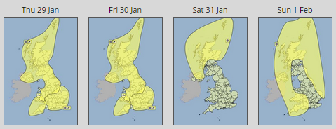
For today (29th January) and Friday, the yellow weather warning affects the whole of the UK, with the exception of south-west England. On Saturday Scotland and Northern Ireland are affected by the warning, and on Sunday, Scotland, Northern Ireland, Wales, south-west England and the east coast of England are affected.

Yellow weather warnings of Snow and Ice for Thursday 29h January, Friday the 30th January, Saturday the 31st of January, and Sunday the 1st of February.
This evening
Wintry showers of snow, sleet and hail are expected through the night and into Friday morning. At lower levels that will be a gradual trend towards rain and sleet, bringing further risk of snow especially on higher ground.
Small area of low pressure is expected to move south eastwards bringing a more persistent spell of rain sleet and snow parts of western Scotland, Northern Ireland, Wales and the Midlands, leading to further accumulations of snow, especially on higher ground.
The public should be aware of potential disruption to travel, and difficult driving conditions.
Friday
In the early hours of Friday morning, more persistent wintry showers are likely to affect parts of Wales, the Midlands and southern England. Accumulations of 1 to 2 cm of snow is possible at low levels, and up to 5 cm could settle locally on higher ground.
Saturday
On Saturday, further snow showers will affect parts of Scotland and Northern Ireland, leading to some locally large accumulations. These showers will be associated with strong winds, so drifting and blizzard conditions are likely.
Sunday
A very cold airmass will continue to spread southwards from Scotland and Northern Ireland across the remainder of the UK on Sunday, accompanied by strong winds. These showers will primarily affect northern parts of Scotland and Northern Ireland but also run along Eastern and Western coastal districts of England and Wales at times. Snow accumulations are likely even at low levels locally.
Have you been affected by the snow? Send us your comments, pictures and videos via our Facebook page.