
On Friday afternoon, on our Facebook page, just ahead of Saturday's storm, we warned of another Low pressure system waiting in the wings, that would affect us on Wednesday, and had the potential to be the worst storm we have seen in recent months. Well in seems that the Low pressure system we were talking about will indeed hit us on Wednesday, in the afternoon, and could last right into Thursday morning. The Met office have today increased weather warnings for Wednesday from Yellow to Amber, and they have warned that there is potential for disruption to travel, and locally to power supplies.
It is unknown at the moment how severe the storm will be, or exactly what track it will take, but this could be a very significant storm and the public should keep up to date with weather and flood warnings.
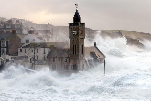
Apart from the possible strong winds, which could potentially bring down more trees and disrupt power supplies, the biggest reason this storm could be very significant is that it will bring more heavy rain, rain that many places in the UK just cannot cope with at the moment. The country is saturated and there simply is nowhere for the rain water to go now, so more rain fall will mean more flooding. Many places around the UK area already facing the worst floods for many years, and there will not be time for flood waters to fully subside before the next wave of rain. It's a situation that could become very bad indeed.
Winds of 60 - 70mph and 80mph in exposed areas are expected, with the South West and Wales expected to be the worst affected. Again, people are advised to not risk getting too close to the sea when the storm is with us.
We will be keeping an eye on the coming storm on the run up to Wednesday. For regular updates visit our Facebook page, click the 'Like' button and then click the 'Follow' button. Updates will then appear in your Facebook news feed.