
Here we go again. Yet another slow moving area of low pressure will move slowly northwards on Wednesday the 5th February, bringing further gale force winds and heavy rain to the south of England, Wales and Northern Ireland.
The Met office have issued an Amber warning of wind for the south east between 8am and 3pm, with winds of 70mph on coasts and 50 - 60mph inland. The winds will affect the region as people start to commute to work and so the public are being urged to be particularly careful and expect disruption to travel. The Met office have warned that falling trees could cause disruption to both travel and power. Winds are expected to be at their strongest at around mid day, and into the early afternoon.
As I write this the Met Office have upgraded the weather warning in the South West of England to Amber. Areas affected by the Amber warning are Dorset, Poole, Bournemouth and Wiltshire. Winds of 70mph on coasts and 50 - 60mph inland are expected.
Current wind conditions...
A Yellow weather warning of wind is in force for the rest of the south of England, south Wales and the east of Northern Ireland. Again, strong gale force winds are expected to cause disruption to travel and possibly power supplies.
Saturated ground and trees weakened by previous storms mean that these new gale force winds are likely to bring down quite a lot of trees. Reports of fallen trees are already coming in. If winds are as strong as expected tomorrow, severe travel disruption on trains and roads are expected. There is also the potential of disruption to power supplies.
Another Yellow severe weather warning of rain is in force for the south of England, Wales, Northern Ireland and the east of Scotland. Rainfall totals of 20-30 mm are expected quite widely with 40 mm or more likely over higher ground. With river levels high and the ground saturated, the public should be aware of the potential for further local flooding.
The Environment Agency currently has 4 severe flood warnings in place to the South West on the south Cornwall coast, Weymouth sea front, West bay harbour and Lyme Regis harbour. A further 64 flood warnings and 213 flood alerts are in place for the rest of the UK. Check the Environment Agency website for floods in your area.
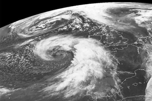
Yesterday, Channel 4 weather man Liam Dutton posted a satellite picture of the Low heading towards us...
Wind gusts now widely reaching 50-60mph, locally 70mph, along southern coasts of Eng & Wales. Here comes the storm... pic.twitter.com/Bboj1pKpJ6
— Liam Dutton (@liamdutton) February 4, 2014
Thousands of people have been affected by a succession of storms over the last three months. Travel delays and cancellations, damage to property from wind and floods, power loss and even loss of life. The news of further storms such as this are anything but welcome and people are wondering when the onslaught will come to and end. It seems we have quite a few days of unsettled weather still to come, with Yellow weather warnings of rain featuring on the Met office website right up until Saturday. The public are advised to keep up to date with weather warnings and flood warnings and be extra careful. Do not attempt to drive through flood water, do not put your life in danger to take photographs of the storm, and during the worst of the weather, restrict travel to essential travel only.
For regular updates visit our Facebook page, click the 'Like' button and then click the 'Follow' button. Updates will then appear in your Facebook news feed.