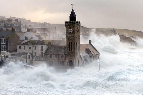
An intense area of low pressure moving over the UK, dubbed Storm Rachel, has caused trees to fall and some structural damage on Wednesday Night (14th January). Many homes are without power and there is likely to be disruption to travel on Thursday morning.
Gusts as strong as 72mph have been recorded at The Needles in the Isle of Wight, and the storm continues to intensify. There is expected to be a period of calm very early on Thursday morning, before winds pick up once again in the north through Thursday.
Update (01:00 Thursday): Gusts of 96mph have been recorded at Capel Curig and Great Dun Fell, North England.
Update (02:10 Thursday): Gusts of 101mph have been recorded in Northern England.
Two Yellow weather warnings of wind are in force for the UK, one for the South of Britain, which reads...
Gales or severe gales are expected to develop across much of England and Wales for a time tonight. Inland gusts may locally exceed 60 mph close to the squally cold front, whilst gusts of 60 to 70 mph seem likely at coastal sites in the south and west, as well as across hills. Gusts may exceed 75 mph in the more exposed coastal locations.
And one for the North, which reads...
South to southwesterly gales or severe gales are expected to develop across areas adjoining the Irish Sea this evening, with gusts reaching 60 to 70 mph in places, possibly around 80 mph in exposed coastal and hilly sites. The winds will ease by midnight, but then after something of a lull, a further spell of very strong winds, this time from the west, is expected from late Thursday morning onwards into the evening, again with gusts of 70 mph or more in places.
Winds have been accompanied by heavy rain in some areas, and the Environment agency has issued 128 flood alerts and 13 more severe Flood warnings. Flood alerts mean that flooding is possible, and to be prepared. Flood warnings mean that flooding is expected and immediate action is required.
Areas currently (At the time of writing this) affected by flood warnings are...
For information on current flood alerts and warnings, visit the Environment Agency website.
A Youtube video showing Storm Rachel hitting County Cork on Wednesday night shows just how intense the winds are...
People affected by storm Rachel have taken to twitter to post pictures of damage caused by the winds...
Looks like a big one! RT @SimpArbTreeCare Emergency call out tonight at Leadenham. Ash tree had fallen across A607. pic.twitter.com/4mtWZ4LTTt
— Radio Lincolnshire (@BBCRadioLincs) January 14, 2015
Tree down at home, and its not looking good at work either! pic.twitter.com/13X556Zwwf
— Watchman (@_watchman) January 14, 2015
Strong winds took a garage down in Harrow and it took down my tree too pic.twitter.com/QlvvkQrs9v
— Jitesh Mistry (@JMist91) January 14, 2015
Harborne High Street CLOSED due to falling debris from the vacant Huntsman Pub. http://t.co/BN9poshdyU pic.twitter.com/WXQXVdJA47
— Birmingham Updates (@BhamUpdates) January 14, 2015
We'll be updating this page with more news on the storm, and more pictures as they become available.
For the latest news on the storm, and the predicted floods, visit our Facebook page, click the 'Like' button and then click the 'Follow' button. Updates will then appear in your Facebook news feed.